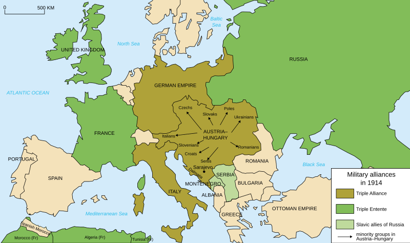
Fasciculus:Map Europe alliances 1914-en.svg

Size of this PNG preview of this SVG file: 800 × 473 elementa imaginalia. Aliae mensurae: 320 × 189 elementa imaginalia | 640 × 379 elementa imaginalia | 1 024 × 606 elementa imaginalia | 1 280 × 758 elementa imaginalia | 2 560 × 1 515 elementa imaginalia | 1 002 × 593 elementa imaginalia.
Sua resolutio (fasciculus SVG, nominale 1 002 × 593 elementa imaginalia, magnitudo fasciculi: 97 chiliocteti)
Historia fasciculi
Presso die vel tempore fasciculum videbis, sicut tunc temporis apparuit.
| Dies/Tempus | Minutio | Dimensiones | Usor | Sententia | |
|---|---|---|---|---|---|
| recentissima | 20:59, 4 Aprilis 2021 |  | 1 002 × 593 (97 chiliocteti) | Andrewtips | File uploaded using svgtranslate tool (https://svgtranslate.toolforge.org/). Added translation for zh-hant. |
| 21:02, 4 Augusti 2020 |  | 1 002 × 593 (92 chiliocteti) | Ionaki | File uploaded using svgtranslate tool (https://svgtranslate.toolforge.org/). Added translation for eu. | |
| 21:02, 4 Augusti 2020 |  | 1 002 × 593 (92 chiliocteti) | Ionaki | File uploaded using svgtranslate tool (https://svgtranslate.toolforge.org/). Added translation for eu. | |
| 20:59, 4 Augusti 2020 |  | 1 002 × 593 (92 chiliocteti) | Ionaki | File uploaded using svgtranslate tool (https://svgtranslate.toolforge.org/). Added translation for eu. | |
| 15:14, 2 Augusti 2020 |  | 1 002 × 593 (72 chiliocteti) | Bogomolov.PL | reservoirs on Dnieper, Don and Volga rivers were built after Second WW, erased. Romania, Serbia, Montenegro, Albania and Bulgaria borders corrected | |
| 11:22, 21 Ianuarii 2017 |  | 1 002 × 593 (75 chiliocteti) | Perey | This portrays the Triple Alliance, not the Central Powers (of which Italy was never one). Error introduced in version dated 2010-03-07 by Mnmazur (talk). | |
| 21:18, 28 Novembris 2015 |  | 1 002 × 593 (75 chiliocteti) | Turnless | Aland Islands | |
| 12:25, 2 Ianuarii 2015 |  | 1 002 × 593 (75 chiliocteti) | Borodun | Moonsund archipelago is territory of Russia | |
| 00:30, 2 Ianuarii 2015 |  | 1 002 × 593 (70 chiliocteti) | ZYjacklin | Capitalize the name for Romania. | |
| 16:49, 17 Novembris 2010 |  | 1 002 × 593 (70 chiliocteti) | Ras67 | "cropped" and minor things |
Nexus ad fasciculum
Nullae paginae hoc fasciculo utuntur.
Usus fasciculi per inceptus Vicimediorum
Quae incepta Vici fasciculo utuntur:
- Usus in ar.wikipedia.org
- Usus in bcl.wikipedia.org
- Usus in bh.wikipedia.org
- Usus in cy.wikipedia.org
- Usus in da.wikipedia.org
- Usus in el.wikipedia.org
- Usus in en.wikipedia.org
- Franz Joseph I of Austria
- Triple Alliance (1882)
- Military alliance
- Triple Entente
- Yugoslav Committee
- Treaty of London (1915)
- Switzerland during the World Wars
- Polish Legions in World War I
- Two-front war
- History of Western civilization
- World War I
- France–Russia relations
- 1914
- European balance of power
- Wikipedia:Graphics Lab/Illustration workshop/Archive/Nov 2010
- Sweden during World War I
- Talk:World War I/Archive 16
- User:Chickstarr404/Gather lists/16060 – "Paris 1919" by Margaret Macmillan
- User:Chickstarr404/Gather lists
- Friedrich von Pourtalès
- Draft:Participants of World War I
- User:Falcaorib/Europe
- Usus in en.wikibooks.org
- Usus in en.wiktionary.org
- Usus in et.wikipedia.org
- Usus in eu.wikipedia.org
- Usus in fa.wikipedia.org
- Usus in fiu-vro.wikipedia.org
- Usus in fi.wikipedia.org
- Usus in fi.wikibooks.org
- Usus in fo.wikipedia.org
- Usus in fy.wikipedia.org
View more global usage of this file.


