
Fasciculus:Dinaric Alps map-fr.svg

Size of this PNG preview of this SVG file: 741 × 600 elementa imaginalia. Aliae mensurae: 297 × 240 elementa imaginalia | 593 × 480 elementa imaginalia | 949 × 768 elementa imaginalia | 1 265 × 1 024 elementa imaginalia | 2 530 × 2 048 elementa imaginalia | 1 857 × 1 503 elementa imaginalia.
Sua resolutio (fasciculus SVG, nominale 1 857 × 1 503 elementa imaginalia, magnitudo fasciculi: 3.63 megaocteti)
Summarium
| Descriptio |
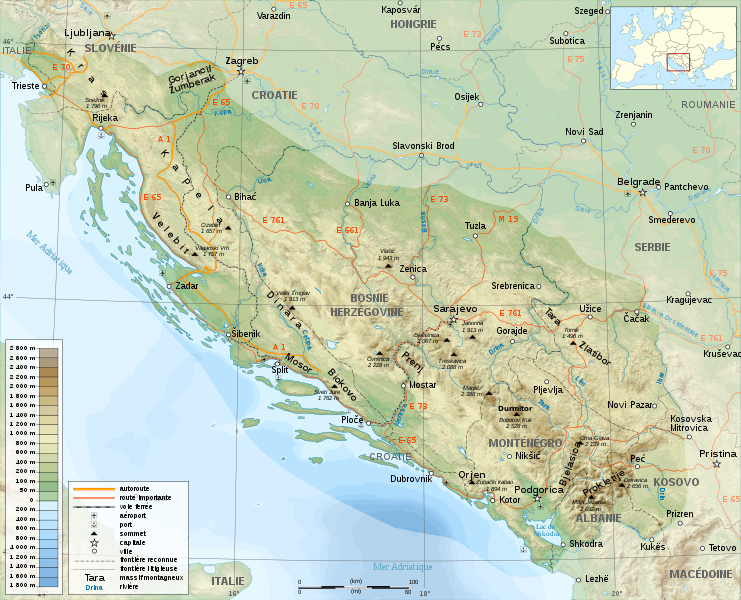
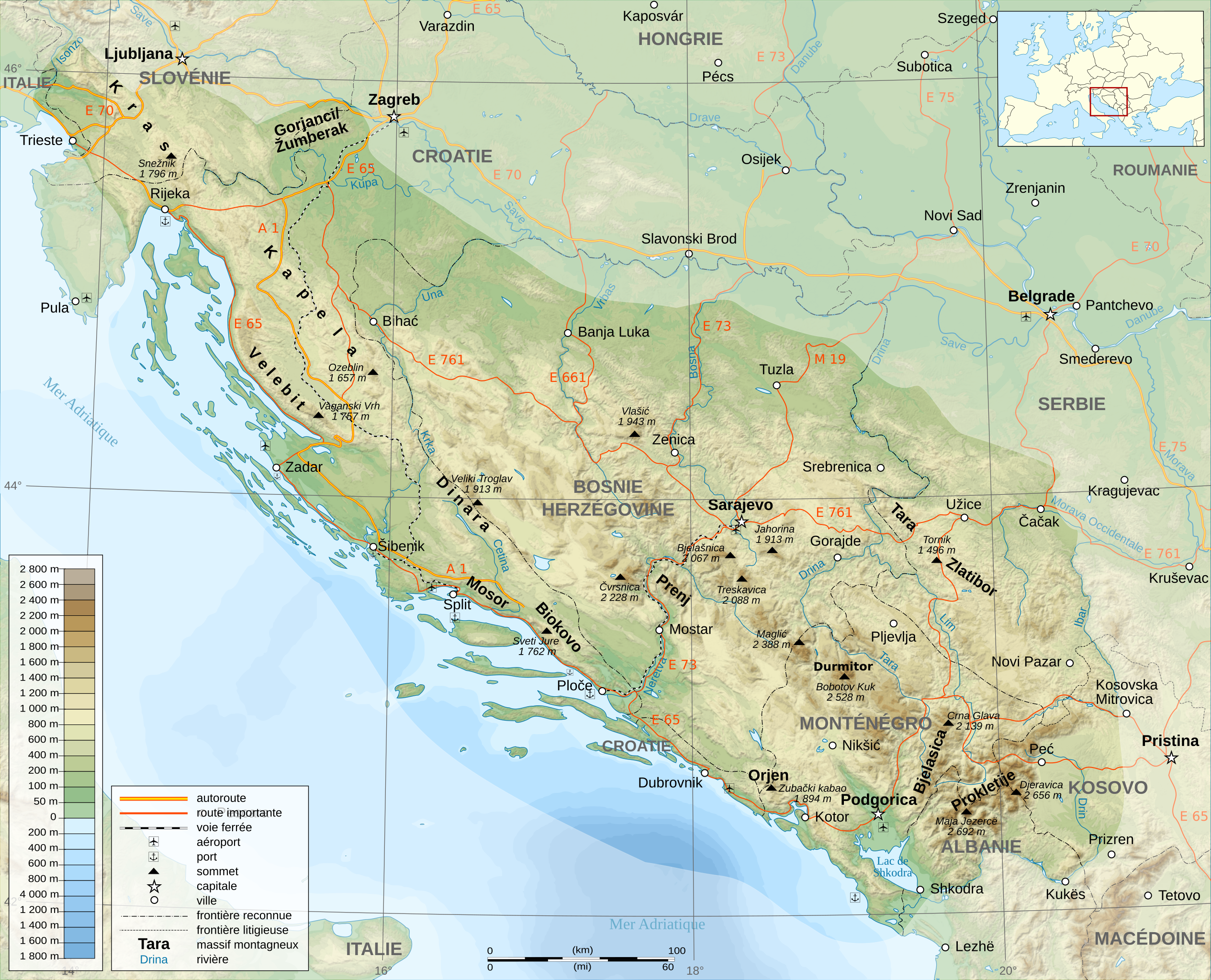
English: A general map of The Dinaric Alps, in French.
Français : Un carte générale de la chaîne des Le Alpes Dinariques. |
||
| Datum | |||
| Fons |
travail personnel (own work). Sources :
Softwares used:
Others:
|
||
| Auctor | Sémhur | ||
| Other versions |
Derivative works of this file: | ||
| Attributio (required by the license) | © Sémhur / Wikimedia Commons / | ||
| SVG | W3C-validity not checked.
|
||
| Graphic Lab |

| Camera location | | View this and other nearby images on: OpenStreetMap |
|---|
Potestas usoris
I, the copyright holder of this work, hereby publish it under the following licenses:
| Copyleft: This work of art is free; you can redistribute it and/or modify it according to terms of the Free Art License. You will find a specimen of this license on the Copyleft Attitude site as well as on other sites. |
This file is licensed under the Creative Commons Attribution-Share Alike Attribution-Share Alike 4.0 International, 3.0 Unported, 2.5 Generic, 2.0 Generic and 1.0 Generic license.
- Tibi licet:
- communicare – copiare, distribuere et committere hoc opus
- to remix – to adapt the work
- His condicionibus:
- attributio – You must give appropriate credit, provide a link to the license, and indicate if changes were made. You may do so in any reasonable manner, but not in any way that suggests the licensor endorses you or your use.
- aequa parte – If you remix, transform, or build upon the material, you must distribute your contributions under the same or compatible license as the original.
Tibi typum permissionis ligere licet.
Historia fasciculi
Presso die vel tempore fasciculum videbis, sicut tunc temporis apparuit.
| Dies/Tempus | Minutio | Dimensiones | Usor | Sententia | |
|---|---|---|---|---|---|
| recentissima | 15:38, 23 Novembris 2008 | | 1 857 × 1 503 (3.63 megaocteti) | Sémhur | Correction autoroutes |
| 21:52, 18 Novembris 2008 |  | 1 857 × 1 503 (3.75 megaocteti) | Sémhur | Bonne version... | |
| 19:26, 18 Novembris 2008 |  | 1 857 × 1 503 (3.58 megaocteti) | Sémhur | Correction du nom d'une montagne. | |
| 19:21, 18 Novembris 2008 |  | 1 857 × 1 503 (3.58 megaocteti) | Sémhur | {{Information |Description={{en|1=General map of Dinaric Alps, in French.}} {{fr|1=Carte générale de la chaîne des Alpes Dinariques.}} |Source=travail personnel (own work). Sources : * Background map : [htt |
Nexus ad fasciculum
Ad hunc fasciculum nectit:
Usus fasciculi per inceptus Vicimediorum
Quae incepta Vici fasciculo utuntur:
- Usus in ca.wikipedia.org
- Usus in fr.wikipedia.org
- Usus in hu.wikipedia.org
- Usus in it.wikipedia.org
- Usus in nn.wikipedia.org