
Fasciculus:Croatia-Dalmatia.png

Mensura huius perspectionis: 625 × 599 elementa imaginalia. Aliae mensurae: 250 × 240 elementa imaginalia | 501 × 480 elementa imaginalia | 801 × 768 elementa imaginalia | 1 068 × 1 024 elementa imaginalia | 1 326 × 1 271 elementa imaginalia.
Sua resolutio (1 326 × 1 271 elementa imaginalia, magnitudo fasciculi: 78 chiliocteti, typus MIME: image/png)
Summarium
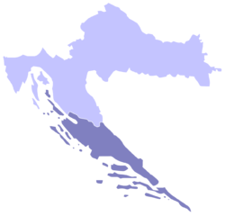
Español: Mapa de Croacia con Dalmacia en azul oscuro
Dalmatia, Croatian region highlighted on map of Croatia.
Made by Shallot who used a map by Morwen.
Potestas usoris

|
Licet hoc documentum exscribere vel distribuere vel demutare sub GNU Liberarum Litterarum Licentiae conditionibus in editione 1.2 aut in ulla editione recentiori a Fundatione Liberarum Programmationis Partium publicata; praeterquam Sectiones Immutabiles et Verba Involucra Adversa et Aversa. Licentiae exemplar praesto est in sectione intitulata GNU Free Documentation License. |
| This file is licensed under the Creative Commons Attribution-Share Alike 3.0 Unported license. | ||
| ||
| This licensing tag was added to this file as part of the GFDL licensing update. |
From en.wikipedia [1]:
![[1]](https://en.wikipedia.org/wiki/Image:Croatia-Dalmatia.png)
- 21:49, 19 March 2004 . . Shallot (Talk) . . 200x198 (20267 bytes) (Croatia with Dalmatia highlighted)
Historia fasciculi
Presso die vel tempore fasciculum videbis, sicut tunc temporis apparuit.
| Dies/Tempus | Minutio | Dimensiones | Usor | Sententia | |
|---|---|---|---|---|---|
| recentissima | 15:11, 30 Aprilis 2012 | | 1 326 × 1 271 (78 chiliocteti) | Kirk979 | new, corrected version |
| 22:09, 15 Decembris 2010 |  | 1 326 × 1 271 (72 chiliocteti) | SpeedyGonsales | Both 2008 and 2010 versions of image were not true/equal to original map (island Rab is added which is not really part of Dalmatia), this image now is true to the original map. | |
| 10:59, 19 Novembris 2010 |  | 1 326 × 1 271 (107 chiliocteti) | P. S. Burton | transparent background | |
| 18:06, 12 Maii 2008 |  | 1 326 × 1 271 (59 chiliocteti) | Пакко | {{Information |Description= |Source= |Date= |Author= |Permission= |other_versions= }} | |
| 13:35, 5 Maii 2005 |  | 200 × 198 (20 chiliocteti) | Alexg~commonswiki | Dalmatia, Croatian region From the english wikipedia, where stated it is {{GFDL}} |
Nexus ad fasciculum
Ad hunc fasciculum nectit:
Usus fasciculi per inceptus Vicimediorum
Quae incepta Vici fasciculo utuntur:
- Usus in af.wikipedia.org
- Usus in als.wikipedia.org
- Usus in am.wikipedia.org
- Usus in an.wikipedia.org
- Usus in be.wikipedia.org
- Usus in br.wikipedia.org
- Usus in bs.wikipedia.org
- Usus in ca.wikipedia.org
- Usus in cs.wikipedia.org
- Usus in cy.wikipedia.org
- Usus in da.wikipedia.org
- Usus in de.wikipedia.org
- Usus in el.wikipedia.org
- Usus in eo.wikipedia.org
- Usus in et.wikipedia.org
- Usus in fur.wikipedia.org
- Usus in fy.wikipedia.org
- Usus in id.wikipedia.org
- Usus in ja.wikipedia.org
- Usus in ka.wikipedia.org
- Usus in ko.wikipedia.org
- Usus in lt.wikipedia.org
- Usus in mk.wikipedia.org
- Usus in ms.wikipedia.org
- Usus in nl.wikipedia.org
- Usus in nn.wikipedia.org
- Usus in os.wikipedia.org
- Usus in pt.wikipedia.org
- Usus in ro.wikipedia.org
- Usus in ru.wikipedia.org
- Usus in sh.wikipedia.org
- Usus in simple.wikipedia.org
- Usus in sk.wikipedia.org
- Usus in sl.wikipedia.org
- Usus in sq.wikipedia.org
- Usus in sw.wikipedia.org
- Usus in tt.wikipedia.org
- Usus in vec.wikipedia.org
- Usus in vi.wikipedia.org
- Usus in zh.wikipedia.org