
Fasciculus:Calcareous Soil Profile, Seven Sisters Country Park - geograph.org.uk - 1280181.jpg
Nulla maior resolutio exstat.
Calcareous_Soil_Profile,_Seven_Sisters_Country_Park_-_geograph.org.uk_-_1280181.jpg (640 × 430 elementa imaginalia, magnitudo fasciculi: 70 chiliocteti, typus MIME: image/jpeg)
Summarium
| Descriptio |
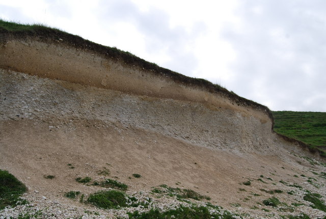
English: Calcareous Soil Profile, Seven Sisters Country Park A well defined soil profile on chalk.
The dark organic ricn humus layer can clearly be seen at the top of the profile. below it is a bleached horizon where nutrients have been leached out & below this is a darker reddish layer of redeposition. At the base of the profile is the weathered bedrock (chalk)the unweathered chalk is hidden. This soil profile is a Rendzina Rendzina |
| Datum | |
| Fons | From geograph.org.uk |
| Auctor | Nigel Chadwick |
| Camera location | | View this and other nearby images on: OpenStreetMap |
|---|
_heading:135.00&language=la)
| Object location | | View this and other nearby images on: OpenStreetMap |
|---|
_heading:135.00&language=la)
Potestas usoris

|
This image was taken from the Geograph project collection. See this photograph's page on the Geograph website for the photographer's contact details. The copyright on this image is owned by Nigel Chadwick and is licensed for reuse under the Creative Commons Attribution-ShareAlike 2.0 license.
|
This file is licensed under the Creative Commons Attribution-Share Alike 2.0 Generic license.
Attributio: Nigel Chadwick
- Tibi licet:
- communicare – copiare, distribuere et committere hoc opus
- to remix – to adapt the work
- His condicionibus:
- attributio – You must give appropriate credit, provide a link to the license, and indicate if changes were made. You may do so in any reasonable manner, but not in any way that suggests the licensor endorses you or your use.
- aequa parte – If you remix, transform, or build upon the material, you must distribute your contributions under the same or compatible license as the original.
Historia fasciculi
Presso die vel tempore fasciculum videbis, sicut tunc temporis apparuit.
| Dies/Tempus | Minutio | Dimensiones | Usor | Sententia | |
|---|---|---|---|---|---|
| recentissima | 05:41, 27 Februarii 2011 | | 640 × 430 (70 chiliocteti) | GeographBot | == {{int:filedesc}} == {{Information |description={{en|1=Calcareous Soil Profile, Seven Sisters Country Park A well defined soil profile on chalk. The dark organic ricn humus layer can clearly be seen at the top of the profile. below it is a bleached hor |
Nexus ad fasciculum
Ad hunc fasciculum nectit:
Usus fasciculi per inceptus Vicimediorum
Quae incepta Vici fasciculo utuntur:
- Usus in ar.wikipedia.org
- Usus in bn.wikipedia.org
- Usus in cy.wikipedia.org
- Usus in de.wikipedia.org
- Usus in en.wikipedia.org
- Usus in es.wikipedia.org
- Usus in fa.wikipedia.org
- Usus in fi.wikipedia.org
- Usus in ha.wikipedia.org
- Usus in mk.wikipedia.org
- Usus in pa.wikipedia.org
- Usus in si.wikipedia.org
- Usus in zh-yue.wikipedia.org