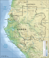
Fasciculus:Topographic map of Gabon-fr.svg

Page contents not supported in other languages.
E Vicipaedia

Sua resolutio(fasciculus SVG, nominale 815 × 965 elementa imaginalia, magnitudo fasciculi: 1.69 megaocteti)

Hic fasciculus apud Vicimedia Communia iacet; in aliis inceptis adhiberi potest. Contenta paginae descriptionis fasciculi subter monstrantur.

Imago (militia) of the year
Featured Imago (militia)

Vicimedia Communia

This is a featured picture on Wikimedia Commons (Featured pictures) and is considered one of the finest images. See its nomination here.

If you have an image of similar quality that can be published under a suitable copyright license, be sure to upload it, tag it, and nominate it.

Summarium

Descriptio
Français : Carte topographique du Gabon.
Datum (English version); 2008-04-03 (French translation)
Fons Traduction de Image:Topographic map of Gabon-en.svg
Auctor Mysid (English version); Bourrichon (French translation)
Other versions

Derivative works of this file:

[recensere]

SVG genesis
InfoField
 
The SVG code is valid.
 
This map was created with Inkscape, or with something else.
Translate this file This SVG file contains embedded text that can be translated into your language, using any capable SVG editor, text editor or the SVG Translate tool. For more information see: About translating SVG files.

Potestas usoris

I, the copyright holder of this work, hereby publish it under the following licenses:
GNU head Licet hoc documentum exscribere vel distribuere vel demutare sub GNU Liberarum Litterarum Licentiae conditionibus in editione 1.2 aut in ulla editione recentiori a Fundatione Liberarum Programmationis Partium publicata; praeterquam Sectiones Immutabiles et Verba Involucra Adversa et Aversa. Licentiae exemplar praesto est in sectione intitulata GNU Free Documentation License.
w:en:Creative Commons
attributio aequa parte
This file is licensed under the Creative Commons Attribution-Share Alike 4.0 International, 3.0 Unported, 2.5 Generic, 2.0 Generic and 1.0 Generic license.
Tibi licet:
  • communicare – copiare, distribuere et committere hoc opus
  • to remix – to adapt the work
His condicionibus:
  • attributio – You must give appropriate credit, provide a link to the license, and indicate if changes were made. You may do so in any reasonable manner, but not in any way that suggests the licensor endorses you or your use.
  • aequa parte – If you remix, transform, or build upon the material, you must distribute your contributions under the same or compatible license as the original.
Tibi typum permissionis ligere licet.

Captions

Add a one-line explanation of what this file represents
Topographical map of Gabon

Items portrayed in this file

depicts Anglica

copyrighted Anglica

16 Februarii 2008

Historia fasciculi

Presso die vel tempore fasciculum videbis, sicut tunc temporis apparuit.

Dies/TempusMinutioDimensionesUsorSententia
recentissima14:21, 3 Aprilis 2008Minutum speculum redactionis 14:21, 3 Aprilis 2008 factae815 × 965 (1.69 megaocteti)Bourrichon{{Information |Description=Traduction de Image:Topographic map of Gabon.svg |Source=travail personnel |Date=3 avril 2008 |Author= Bourrichon |Permission= |other_versions= <gallery> Image:Topographic map of Gabon.svg|''en'' </galle

Ad hunc fasciculum nectit:

Usus fasciculi per inceptus Vicimediorum