
Fasciculus:Saharan topographic elements map.png
Mensura huius perspectionis: 800 × 395 elementa imaginalia. Aliae mensurae: 320 × 158 elementa imaginalia | 640 × 316 elementa imaginalia | 1 396 × 690 elementa imaginalia.
Sua resolutio (1 396 × 690 elementa imaginalia, magnitudo fasciculi: 757 chiliocteti, typus MIME: image/png)
Summarium
| Descriptio |
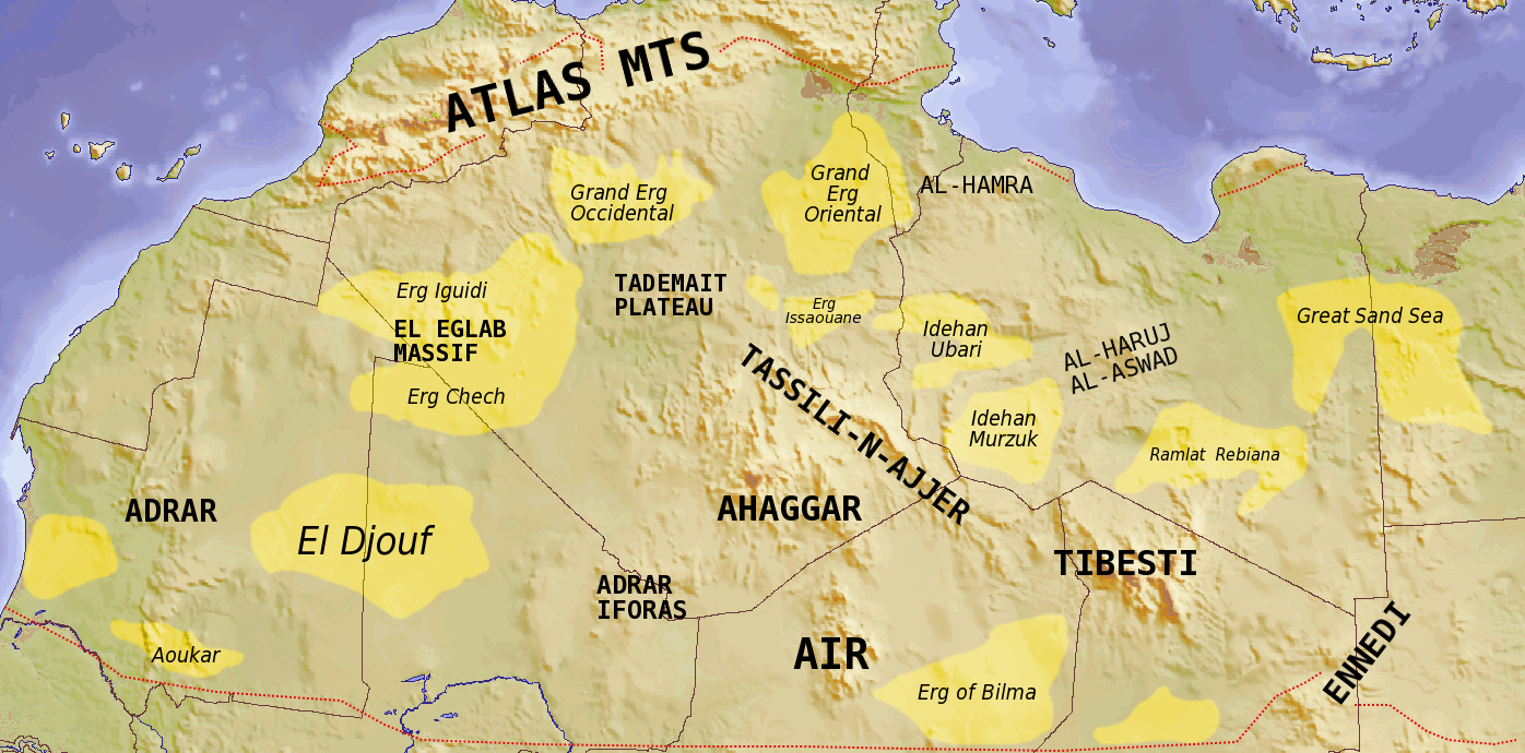
English: Map showing major Dune seas (ergs) and Mountain ranges of the Sahara. Red dashed line shows approximate limit of the Sahara. National borders in grey. Dune seas in yellow.
Derived from Blank map Image:Africa_topography_map_with_borders.png. Data taken from http://www.sahara-overland.com image of Michlein Map and Geology.com's Sahara Desert Map.
العربية: السمات الطبوغرافية الرئيسية للمنطقة الصحراوية |
|
| Datum | ||
| Fons | Own work by uploader Derived from Blank map Image:Africa_topography_map_with_borders.png | |
| Auctor | T L Miles | |
| Other versions |
File:Africa_topography_map_with_borders.png
|

Potestas usoris
I, the copyright holder of this work, hereby publish it under the following licenses:
This file is licensed under the Creative Commons Attribution-Share Alike 3.0 Unported license.
- Tibi licet:
- communicare – copiare, distribuere et committere hoc opus
- to remix – to adapt the work
- His condicionibus:
- attributio – You must give appropriate credit, provide a link to the license, and indicate if changes were made. You may do so in any reasonable manner, but not in any way that suggests the licensor endorses you or your use.
- aequa parte – If you remix, transform, or build upon the material, you must distribute your contributions under the same or compatible license as the original.

|
Licet hoc documentum exscribere vel distribuere vel demutare sub GNU Liberarum Litterarum Licentiae conditionibus in editione 1.2 aut in ulla editione recentiori a Fundatione Liberarum Programmationis Partium publicata; praeterquam Sectiones Immutabiles et Verba Involucra Adversa et Aversa. Licentiae exemplar praesto est in sectione intitulata GNU Free Documentation License. |
Tibi typum permissionis ligere licet.
| Annotations | This image is annotated: View the annotations at Commons |
Historia fasciculi
Presso die vel tempore fasciculum videbis, sicut tunc temporis apparuit.
| Dies/Tempus | Minutio | Dimensiones | Usor | Sententia | |
|---|---|---|---|---|---|
| recentissima | 18:39, 24 Iulii 2008 | | 1 396 × 690 (757 chiliocteti) | T L Miles | {{Information |Description={{en|1=Map showing major Dune seas (ergs) and Mountain ranges of the Sahara. Red dashed line shows approximate limit of the Sahara. National borders in grey. Dune seas in yellow. Derived from Blank map [[:Image:Africa_topogra |
Nexus ad fasciculum
Ad hunc fasciculum nectit:
Usus fasciculi per inceptus Vicimediorum
Quae incepta Vici fasciculo utuntur:
- Usus in af.wikipedia.org
- Usus in ar.wikipedia.org
- Usus in arz.wikipedia.org
- Usus in az.wikipedia.org
- Usus in ba.wikipedia.org
- Usus in be.wikipedia.org
- Usus in bg.wikipedia.org
- Usus in cs.wikipedia.org
- Usus in da.wikipedia.org
- Usus in de.wikipedia.org
- Usus in en.wikipedia.org
- Usus in eo.wikipedia.org
- Usus in es.wikipedia.org
- Usus in eu.wikipedia.org
- Usus in fa.wikipedia.org
- Usus in fi.wikipedia.org
- Usus in frr.wikipedia.org
- Usus in fr.wikipedia.org
View more global usage of this file.