
Fasciculus:Northern Mali conflict.svg

Size of this PNG preview of this SVG file: 629 × 600 elementa imaginalia. Aliae mensurae: 252 × 240 elementa imaginalia | 503 × 480 elementa imaginalia | 805 × 768 elementa imaginalia | 1 074 × 1 024 elementa imaginalia | 2 148 × 2 048 elementa imaginalia | 1 316 × 1 255 elementa imaginalia.
Sua resolutio (fasciculus SVG, nominale 1 316 × 1 255 elementa imaginalia, magnitudo fasciculi: 796 chiliocteti)
Summarium
| Descriptio |
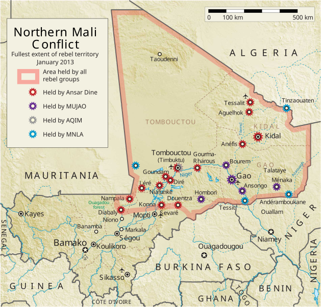
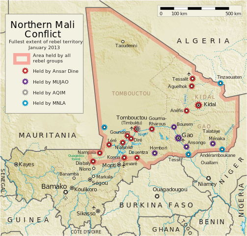
English: Map of the conflict in Northern Mali. (English)
العربية: خريطة الصّراع في شمال مالي. (إنجليزي)
Français : Carte du conflit au nord du Mali. (Anglais)
Latina: Charta rebellionis Tuaregorum in Malia septentrionali. (Anglice)
Українська: Карта конфлікту на півночі Малі. (Англійською) |
| Fons |
Opus proprium This vector image includes elements that have been taken or adapted from this file: This vector image includes elements that have been taken or adapted from this file: |
| Auctor | Orionist |
| Other versions | German/Deutsch/Allemand, French/Français, Macedonian/македонски јазик/Macédonien |
| SVG genesis |
Notes
- ↑ US Department of State, "Country Reports on Terrorism 2011", Chapter 2 Country Reports: Africa Overview, 31 July 2012
Potestas usoris
I, the copyright holder of this work, hereby publish it under the following license:
This file is licensed under the Creative Commons Attribution-Share Alike 3.0 Unported license.
- Tibi licet:
- communicare – copiare, distribuere et committere hoc opus
- to remix – to adapt the work
- His condicionibus:
- attributio – You must give appropriate credit, provide a link to the license, and indicate if changes were made. You may do so in any reasonable manner, but not in any way that suggests the licensor endorses you or your use.
- aequa parte – If you remix, transform, or build upon the material, you must distribute your contributions under the same or compatible license as the original.
Historia fasciculi
Presso die vel tempore fasciculum videbis, sicut tunc temporis apparuit.
| Dies/Tempus | Minutio | Dimensiones | Usor | Sententia | |
|---|---|---|---|---|---|
| recentissima | 06:59, 8 Aprilis 2014 | | 1 316 × 1 255 (796 chiliocteti) | Ansh666 | Reverted to version as of 16:51, 8 March 2013 - restoring the correct version, as the map is supposed to be historical, not current |
| 20:15, 5 Decembris 2013 |  | 1 316 × 1 255 (699 chiliocteti) | Hanibal911 | more accurately reflects the situation | |
| 16:51, 8 Martii 2013 |  | 1 316 × 1 255 (796 chiliocteti) | Agricolae | Hombori dot restored | |
| 14:29, 5 Martii 2013 |  | 1 316 × 1 255 (794 chiliocteti) | TUFKAAP | Since this is an English map, Al-Qaeda in the Islamic Maghreb should be abbreviated as AQIM. | |
| 03:33, 11 Februarii 2013 |  | 1 316 × 1 255 (794 chiliocteti) | Agricolae | shift text distorted on upload | |
| 03:27, 11 Februarii 2013 |  | 1 316 × 1 255 (794 chiliocteti) | Agricolae | change to show greatest extent - see WP Talk:Northern Mali conflict (2012–present) | |
| 06:36, 8 Februarii 2013 |  | 1 316 × 1 255 (699 chiliocteti) | Rama | Aguelhok contested or taken ( http://www.lemonde.fr/afrique/article/2013/02/08/mali-les-forces-francaise-et-tchadiennes-a-aguelhok_1828906_3212.html ) | |
| 10:29, 2 Februarii 2013 |  | 1 316 × 1 255 (698 chiliocteti) | U5K0 | Bourem to green as per talk page | |
| 08:41, 30 Ianuarii 2013 |  | 1 316 × 1 255 (679 chiliocteti) | Orionist | Updated map: Menaka, Anderamboukane, Ansongo, Dire, Kidal and other MNLA positions. Removed rebel area boundaries as the situation has become complicated. | |
| 17:23, 29 Ianuarii 2013 |  | 1 316 × 1 255 (894 chiliocteti) | Jaybear | Insertion of a map-scale in the upper right corner (added directly before the token "/svg" at end of svg-code); |
Nexus ad fasciculum
Ad hunc fasciculum nectit:
Usus fasciculi per inceptus Vicimediorum
Quae incepta Vici fasciculo utuntur:
- Usus in af.wikipedia.org
- Usus in ar.wikipedia.org
- Usus in azb.wikipedia.org
- Usus in az.wikipedia.org
- Usus in bg.wikipedia.org
- Usus in bn.wikipedia.org
- Usus in ca.wikipedia.org
- Usus in cs.wikipedia.org
- Usus in cy.wikipedia.org
- Usus in da.wikipedia.org
- Usus in de.wikipedia.org
- Usus in el.wikipedia.org
- Usus in en.wikipedia.org
- Mali
- Portal:Mali
- Insurgency in the Maghreb (2002–present)
- War on terror
- User:Orionist/Gallery
- National Movement for the Liberation of Azawad
- Wikipedia talk:WikiProject Maps/Archive 2012
- Wikipedia:In the news/Candidates/April 2012
- Wikipedia:Graphics Lab/Map workshop/Archive/Apr 2012
- Wikipedia:Wikipedia Signpost/2012-04-30/WikiProject report
- Wikipedia:Wikipedia Signpost/Single/2012-04-30
- Mali War
- Wikipedia:WikiProject Maps/Conventions/Pushpin maps
- Operation Serval
- Chadian intervention in northern Mali
- Islamist insurgency in the Sahel
- User:AlbanianEditor1990/sandbox
- Usus in en.wikinews.org
- Usus in eo.wikipedia.org
- Usus in es.wikipedia.org
- Usus in et.wikipedia.org
- Usus in eu.wikipedia.org
- Usus in fi.wikipedia.org
View more global usage of this file.