
Fasciculus:Map of Virginia highlighting Hanover County.svg

Size of this PNG preview of this SVG file: 800 × 347 elementa imaginalia. Aliae mensurae: 320 × 139 elementa imaginalia | 640 × 278 elementa imaginalia | 1 024 × 444 elementa imaginalia | 1 280 × 555 elementa imaginalia | 2 560 × 1 110 elementa imaginalia | 7 486 × 3 247 elementa imaginalia.
Sua resolutio (fasciculus SVG, nominale 7 486 × 3 247 elementa imaginalia, magnitudo fasciculi: 223 chiliocteti)
Summarium
| Descriptio |
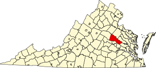
English: This is a locator map showing Hanover County in Virginia. For more information, see Commons:United States county locator maps. |
| Datum | |
| Fons |
Opus proprium: English: The maps use data from nationalatlas.gov, specifically countyp020.tar.gz on the Raw Data Download page. The maps also use state outline data from statesp020.tar.gz. The Florida maps use hydrogm020.tar.gz to display Lake Okeechobee. |
| Auctor | David Benbennick |
| SVG genesis |
Potestas usoris
| I, the copyright holder of this work, release this work into the public domain. This applies worldwide. In some countries this may not be legally possible; if so: I grant anyone the right to use this work for any purpose, without any conditions, unless such conditions are required by law. |
Historia fasciculi
Presso die vel tempore fasciculum videbis, sicut tunc temporis apparuit.
| Dies/Tempus | Minutio | Dimensiones | Usor | Sententia | |
|---|---|---|---|---|---|
| recentissima | 17:47, 12 Februarii 2006 | | 7 486 × 3 247 (223 chiliocteti) | David Benbennick | {{subst:User:Dbenbenn/clm|county=Hanover County|state=Virginia|type=county}} |
Nexus ad fasciculum
Nullae paginae hoc fasciculo utuntur.
Usus fasciculi per inceptus Vicimediorum
Quae incepta Vici fasciculo utuntur:
- Usus in ar.wikipedia.org
- Usus in bg.wikipedia.org
- Usus in bpy.wikipedia.org
- Usus in ca.wikipedia.org
- Usus in cdo.wikipedia.org
- Usus in ceb.wikipedia.org
- Usus in ce.wikipedia.org
- Usus in cy.wikipedia.org
- Usus in de.wikipedia.org
- Usus in en.wikipedia.org
- List of cities and counties in Virginia
- Hanover County, Virginia
- Ashland, Virginia
- Mechanicsville, Virginia
- Doswell, Virginia
- Montpelier, Hanover County, Virginia
- Rockville, Virginia
- Beaverdam, Virginia
- Old Church, Virginia
- Elmont, Virginia
- Pamunkey River
- Hanover, Virginia
- Ashland station (Virginia)
- Template:Hanover County, Virginia
- National Register of Historic Places listings in Hanover County, Virginia
- Template:HanoverCountyVA-geo-stub
- User:Nyttend/County templates/VA/1
- User:LBourne/Scratch pad
- Cold Harbor, Virginia
- Category:Populated places in Hanover County, Virginia
- Studley, Virginia
- Negro Foot, Virginia
- Green Bay, Hanover County, Virginia
- Atlee, Virginia
- User:Nyttend/Virginia NRHP/Hanover
- List of census-designated places in Virginia
- Usus in es.wikipedia.org
- Usus in eu.wikipedia.org
- Usus in fa.wikipedia.org
View more global usage of this file.