
Fasciculus:Map of Kansas highlighting Wilson County.svg

Size of this PNG preview of this SVG file: 800 × 410 elementa imaginalia. Aliae mensurae: 320 × 164 elementa imaginalia | 640 × 328 elementa imaginalia | 1 024 × 525 elementa imaginalia | 1 280 × 656 elementa imaginalia | 2 560 × 1 313 elementa imaginalia | 6 607 × 3 388 elementa imaginalia.
Sua resolutio (fasciculus SVG, nominale 6 607 × 3 388 elementa imaginalia, magnitudo fasciculi: 24 chiliocteti)
| Descriptio |
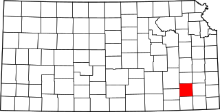
English: This is a locator map showing Wilson County in Kansas. |
| Fons | Opus proprium |
| Auctor | David Benbennick made this map. For more information, see Commons:United States county locator maps. |
| I, the copyright holder of this work, release this work into the public domain. This applies worldwide. In some countries this may not be legally possible; if so: I grant anyone the right to use this work for any purpose, without any conditions, unless such conditions are required by law. |
Historia fasciculi
Presso die vel tempore fasciculum videbis, sicut tunc temporis apparuit.
| Dies/Tempus | Minutio | Dimensiones | Usor | Sententia | |
|---|---|---|---|---|---|
| recentissima | 12:20, 12 Februarii 2006 | | 6 607 × 3 388 (24 chiliocteti) | David Benbennick | {{subst:User:Dbenbenn/clm|county=Wilson County|state=Kansas}} |
Nexus ad fasciculum
Ad hunc fasciculum nectit:
Usus fasciculi per inceptus Vicimediorum
Quae incepta Vici fasciculo utuntur:
- Usus in ar.wikipedia.org
- Usus in bg.wikipedia.org
- Usus in bpy.wikipedia.org
- Usus in cdo.wikipedia.org
- Usus in ceb.wikipedia.org
- Usus in ce.wikipedia.org
- Usus in cs.wikipedia.org
- Usus in cy.wikipedia.org
- Usus in de.wikipedia.org
- Usus in en.wikipedia.org
- List of counties in Kansas
- Wilson County, Kansas
- Altoona, Kansas
- Benedict, Kansas
- Buffalo, Kansas
- Coyville, Kansas
- Fredonia, Kansas
- Neodesha, Kansas
- New Albany, Kansas
- Template:Wilson County, Kansas
- User:Nyttend/County templates/KS/2
- National Register of Historic Places listings in Wilson County, Kansas
- Category:Populated places in Wilson County, Kansas
- Buxton, Kansas
- Lafontaine, Kansas
- Vilas, Kansas
- Cedar Township, Wilson County, Kansas
- Guilford Township, Wilson County, Kansas
- Roper, Kansas
- Chetopa Township, Wilson County, Kansas
- Pleasant Valley Township, Wilson County, Kansas
- Colfax Township, Wilson County, Kansas
- Talleyrand Township, Wilson County, Kansas
- Duck Creek Township, Wilson County, Kansas
- Newark Township, Wilson County, Kansas
- Prairie Township, Wilson County, Kansas
- Webster Township, Wilson County, Kansas
- Verdigris Township, Wilson County, Kansas
- Fall River Township, Wilson County, Kansas
- Clifton Township, Wilson County, Kansas
- Center Township, Wilson County, Kansas
- Neodesha Township, Wilson County, Kansas
- Rest, Kansas
- Usus in es.wikipedia.org
- Usus in et.wikipedia.org
- Usus in eu.wikipedia.org
- Usus in fa.wikipedia.org
View more global usage of this file.