
Fasciculus:Map Denmark Demis SE islands.gif
Nulla maior resolutio exstat.
Map_Denmark_Demis_SE_islands.gif (415 × 420 elementa imaginalia, magnitudo fasciculi: 23 chiliocteti, typus MIME: image/gif)
Summarium
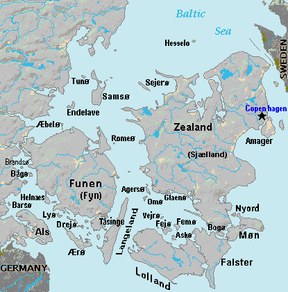
| Descriptio | Terrain map of southeast Denmark, showing the major islands labeled, in the region between Germany and Sweden. The terrain data was extracted from the Demis map (on Wikimedia Commons) Image:La2-demis-denmark.png, and the extracted map was color-shifted to grayshade land areas (from the green Demis map). Labels are in font face Arial or Arial Narrow, sizes 8-10. |
| Datum | |
| Fons | Derivative of Demis map: Image:La2-demis-denmark.png |
| Auctor | Wikid77 (derivative of Demis map) |
Potestas usoris
This image is in the public domain because it came from the site https://www.demis.nl/products/web-map-server/examples/ and was released by the copyright holder. Permission is granted to copy, distribute and/or modify this map since it is based on free of copyright images from: www.demis.nl. See also approval email on de.wp and its clarification.
|
| This work has been released into the public domain by its copyright holder, www.demis.nl. This applies worldwide. In some countries this may not be legally possible; if so: www.demis.nl grants anyone the right to use this work for any purpose, without any conditions, unless such conditions are required by law.
|
Historia fasciculi
Presso die vel tempore fasciculum videbis, sicut tunc temporis apparuit.
| Dies/Tempus | Minutio | Dimensiones | Usor | Sententia | |
|---|---|---|---|---|---|
| recentissima | 18:51, 3 Septembris 2007 | | 415 × 420 (23 chiliocteti) | Wikid77 | added 14 island names |
| 10:50, 2 Septembris 2007 |  | 415 × 420 (22 chiliocteti) | Wikid77 | added "Sejero" + "Amager" | |
| 12:56, 1 Septembris 2007 |  | 415 × 420 (22 chiliocteti) | Wikid77 | cut height 10px for square/undistorted resizing; cut banner "DENMARK" to appear in banner version | |
| 12:46, 1 Septembris 2007 |  | 415 × 430 (22 chiliocteti) | Wikid77 | cut map width 10px as 415px magnified 3%; banner "DENMARK"; enlarged names; darkened Germany/Sweden | |
| 13:36, 31 Augusti 2007 |  | 425 × 430 (22 chiliocteti) | Wikid77 | Terrain map of southeast Denmark, showing the major islands labeled, in the region between Germany and Sweden. The terrain data was extracted from the Demis map (on Wikimedia Commons) Image:La2-demis-denmark.png , and the extracted map w |
Nexus ad fasciculum
Ad hunc fasciculum nectit:
Usus fasciculi per inceptus Vicimediorum
Quae incepta Vici fasciculo utuntur:
- Usus in da.wikipedia.org
- Usus in el.wikipedia.org
- Usus in en.wikipedia.org
- Usus in es.wikipedia.org
- Usus in fi.wikipedia.org
- Usus in fr.wikipedia.org
- Usus in gl.wikipedia.org
- Usus in hr.wikipedia.org
- Usus in it.wikipedia.org
- Usus in ka.wikipedia.org
- Usus in lt.wikipedia.org
- Usus in pt.wikipedia.org
- Usus in sl.wikipedia.org
- Usus in vi.wikipedia.org
- Usus in zh.wikipedia.org