
Fasciculus:Kyrgyzstan provinces map.png
Nulla maior resolutio exstat.
Kyrgyzstan_provinces_map.png (750 × 423 elementa imaginalia, magnitudo fasciculi: 13 chiliocteti, typus MIME: image/png)
Summarium
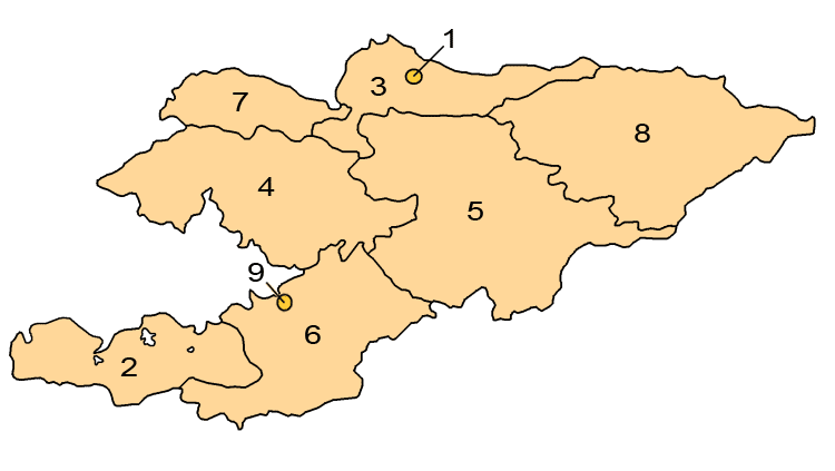
Map showing the provinces and districts of Kyrgyzstan, including the indepedent cities of Bishkek and Osh. This map is an updated version of Image:KyrgyzstanNumbered.png, which was created by w:en:user:Aivazovsky.
Potestas usoris

|
Licet hoc documentum exscribere vel distribuere vel demutare sub GNU Liberarum Litterarum Licentiae conditionibus in editione 1.2 aut in ulla editione recentiori a Fundatione Liberarum Programmationis Partium publicata; praeterquam Sectiones Immutabiles et Verba Involucra Adversa et Aversa. Licentiae exemplar praesto est in sectione intitulata GNU Free Documentation License. |
| This file is licensed under the Creative Commons Attribution-Share Alike 3.0 Unported license. | ||
| ||
| This licensing tag was added to this file as part of the GFDL licensing update. |
Historia fasciculi
Presso die vel tempore fasciculum videbis, sicut tunc temporis apparuit.
| Dies/Tempus | Minutio | Dimensiones | Usor | Sententia | |
|---|---|---|---|---|---|
| recentissima | 01:24, 1 Aprilis 2008 | | 750 × 423 (13 chiliocteti) | Hux | ==Summary== Map showing the provinces and districts of Kyrgyzstan, including the indepedent cities of Bishkek and Osh. This map is an updated version of Image:KyrgyzstanNumbered.png, which was created by w:en:user:Aivazovsky. ==Licensing== {{GFD |
Nexus ad fasciculum
Ad hunc fasciculum nectunt:
Usus fasciculi per inceptus Vicimediorum
Quae incepta Vici fasciculo utuntur:
- Usus in ace.wikipedia.org
- Usus in af.wikipedia.org
- Usus in ar.wikipedia.org
- Usus in arz.wikipedia.org
- Usus in az.wikipedia.org
- Usus in ca.wikipedia.org
- Usus in cs.wikipedia.org
- Usus in de.wikipedia.org
- Usus in en.wikipedia.org
- Usus in es.wikipedia.org
- Usus in eu.wikipedia.org
- Usus in fa.wikipedia.org
- Usus in fr.wikipedia.org
- Usus in he.wikipedia.org
- Usus in hi.wikipedia.org
- Usus in hr.wikipedia.org
- Usus in hu.wikipedia.org
- Usus in id.wikipedia.org
- Usus in is.wikipedia.org
View more global usage of this file.