
Fasciculus:Crete relief map.svg

Size of this PNG preview of this SVG file: 800 × 380 elementa imaginalia. Aliae mensurae: 320 × 152 elementa imaginalia | 640 × 304 elementa imaginalia | 1 024 × 486 elementa imaginalia | 1 280 × 607 elementa imaginalia | 2 560 × 1 215 elementa imaginalia | 3 370 × 1 599 elementa imaginalia.
Sua resolutio (fasciculus SVG, nominale 3 370 × 1 599 elementa imaginalia, magnitudo fasciculi: 1.21 megaocteti)
Summarium
| Descriptio |
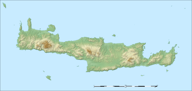
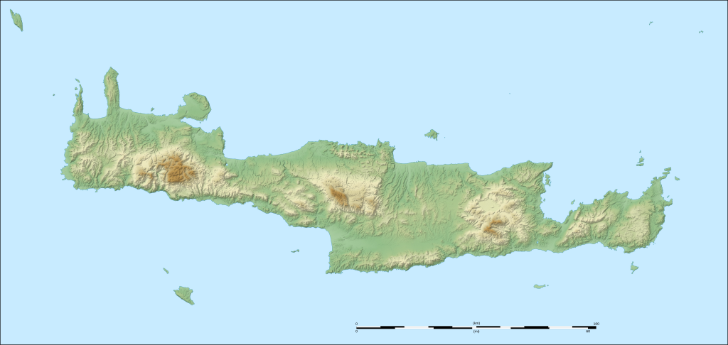
English: Blank physical map of Crete, Greece. Note: The background map is a raster image embedded in the SVG file. Français : Carte physique de la Crète, Grèce. UTM projection ; WGS84 datum ; shaded reliefNote: Le fond de carte est une image bitmap embarquée dans le fichier SVG. |
| Datum | (UTC) |
| Fons | |
| Auctor |
|
| This is a retouched picture, which means that it has been digitally altered from its original version. The original can be viewed here: Crete relief map-fr.svg:
|
Potestas usoris
I, the copyright holder of this work, hereby publish it under the following licenses:
This file is licensed under the Creative Commons Attribution-Share Alike 3.0 Unported, 2.5 Generic, 2.0 Generic and 1.0 Generic license.
- Tibi licet:
- communicare – copiare, distribuere et committere hoc opus
- to remix – to adapt the work
- His condicionibus:
- attributio – You must give appropriate credit, provide a link to the license, and indicate if changes were made. You may do so in any reasonable manner, but not in any way that suggests the licensor endorses you or your use.
- aequa parte – If you remix, transform, or build upon the material, you must distribute your contributions under the same or compatible license as the original.

|
Licet hoc documentum exscribere vel distribuere vel demutare sub GNU Liberarum Litterarum Licentiae conditionibus in editione 1.2 aut in ulla editione recentiori a Fundatione Liberarum Programmationis Partium publicata; praeterquam Sectiones Immutabiles et Verba Involucra Adversa et Aversa. Licentiae exemplar praesto est in sectione intitulata GNU Free Documentation License. |
Tibi typum permissionis ligere licet.
Original upload log
This image is a derivative work of the following images:
- File:Crete_relief_map-fr.svg licensed with Cc-by-sa-3.0,2.5,2.0,1.0, GFDL
- 2008-09-06T21:10:51Z Sting 3370x1599 (1384095 Bytes) New standard colors
- 2007-10-12T18:22:46Z Sting 3370x1599 (1414147 Bytes) Typo correction ; additional names
- 2007-10-10T22:58:10Z Sting 3370x1599 (1411524 Bytes) {{Information |Description=Map in French of the relief of [[:en:Crete|Crete]], Greece |Source=Own work ;Topographic background map : [http://www2.jpl.nasa.gov/srtm NASA Shuttle Radar Topography Mission] (SRTM3 v.2) (public do
Uploaded with derivativeFX
Historia fasciculi
Presso die vel tempore fasciculum videbis, sicut tunc temporis apparuit.
| Dies/Tempus | Minutio | Dimensiones | Usor | Sententia | |
|---|---|---|---|---|---|
| recentissima | 16:38, 28 Octobris 2010 | | 3 370 × 1 599 (1.21 megaocteti) | Xfigpower | {{Information |Description={{en|Physical map in French of Crete, Greece.<br/>''Note:'' The background map is a raster image embedded in the SVG file.}} {{fr|Carte physique de la Crète, Grèce.<br/>''Note:'' Le fond de carte e |
Nexus ad fasciculum
Ad hunc fasciculum nectunt:
- Anemospelia
- Archanae (urbs Minoa)
- Cnossus
- Gurnia
- Malia (urbs Minoa)
- Mochlus (locus archaeologicus)
- Monasteracium (urbs Minoa)
- Palaeocastrum (urbs Minoa)
- Papadiocampus
- Phaestus
- Phurnu Coryphe
- Placias (loci archaeologici)
- Psira
- Pyrgus Myrti
- Sancta Trinitas (Creta)
- Spelunca Geranii
- Spelunca Lera
- Zacrus (urbs Minoa)
- Formula:Charta locatrix Cretae physicalis
Usus fasciculi per inceptus Vicimediorum
Quae incepta Vici fasciculo utuntur:
- Usus in az.wikipedia.org
- Usus in ba.wikipedia.org
- Usus in bg.wikipedia.org
- Usus in cv.wikipedia.org
- Usus in de.wikipedia.org
- Kreta
- Höhle von Psychro
- Spinalonga
- Chrysi
- Kournas-See
- Kloster Preveli
- Dia (Insel)
- Koufonisi
- Gavdopoula
- Psira
- Paximadia-Inseln
- Dikti
- Elafonisi (Kreta)
- Theodorou
- Voulismeni-See
- Wikipedia:Kartenwerkstatt/Positionskarten/Europa
- Dionysaden
- Nikolos
- Agia Paraskevi (Kalogeros)
- Vorlage:Positionskarte Griechenland Kreta
- Imeri Gramvousa
- Agria Gramvousa
- Fortezza von Rethymno
- Spinalonga-Halbinsel
- Sideros
- Naos Panagias (Thronos)
- Paralia Episkopis
- Potamon-See
- Psili Korfi (Giouchtas)
- Karfi
- Mikri Koprana
- Megali Koprana
- Agios Georgios Papoura
- Pass von Ambelos
- Paralia Diaskari
- Paralia Langada
- Paralia Vourlia
- Paralia Argilos
- Paralia Gerondolakkos
- Kavali
View more global usage of this file.