
Fasciculus:Bering Sea Location.png
Bering_Sea_Location.png (700 × 375 elementa imaginalia, magnitudo fasciculi: 116 chiliocteti, typus MIME: image/png)
La bildo estas kopiita de wikipedia:en. La originala priskribo estas:
Summarium
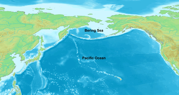
Map showing the Bering Sea and its location in the Pacific Ocean. Created from a composite of two maps on Wikimedia Commons: Image:Topographic90deg N0E90.png Image:Topographic90deg N0W90.png
Potestas usoris

|
Licet hoc documentum exscribere vel distribuere vel demutare sub GNU Liberarum Litterarum Licentiae conditionibus in editione 1.2 aut in ulla editione recentiori a Fundatione Liberarum Programmationis Partium publicata; praeterquam Sectiones Immutabiles et Verba Involucra Adversa et Aversa. Licentiae exemplar praesto est in sectione intitulata GNU Free Documentation License. |
| This file is licensed under the Creative Commons Attribution-Share Alike 3.0 Unported license. | ||
| ||
| This licensing tag was added to this file as part of the GFDL licensing update. |
| date/time | username | edit summary |
|---|---|---|
| 23:41, 18 December 2005 | en:User:DanMS | (Map showing the Bering Sea and its location in the Pacific Ocean. Created from a composite of two maps on Wikimedia Commons: [http://commons.wikimedia.org/wiki/Image:Topographic90deg_N0E90.png] [http://commons.wikimedia.org/wiki/Image:Topographic90deg_N0W) |
Original upload log
Legend: (cur) = this is the current file, (del) = delete this old version, (rev) = revert to this old version.
Click on date to download the file or see the image uploaded on that date.
- (del) (cur) 23:41, 18 December 2005 . . en:User:DanMS DanMS ( en:User_talk:DanMS Talk) . . 700x375 (114665 bytes) (Map showing the Bering Sea and its location in the Pacific Ocean. Created from a composite of two maps on Wikimedia Commons: Image:Topographic90deg N0E90.png [http://commons.wikimedia.org/wiki/Image:Topographic90deg_N0W)
en:Image:Bering Sea Location.gif
Original upload log
| Dies/Tempus | Dimensiones | Usor | Sententia |
|---|---|---|---|
| 26 Martius 2006, 07:23:19 | 700 × 375 (114665 bytes) | Maksim (disputatio · conlationes) | La bildo estas kopiita de wikipedia:en. La originala priskribo estas: == Summary == Map showing the Bering Sea and its location in the Pacific Ocean. Created from a composite of two maps on Wikimedia Commons: [http://commons.wikimedia.org/wiki/Image:Topo |
Historia fasciculi
Presso die vel tempore fasciculum videbis, sicut tunc temporis apparuit.
| Dies/Tempus | Minutio | Dimensiones | Usor | Sententia | |
|---|---|---|---|---|---|
| recentissima | 03:07, 24 Augusti 2014 | | 700 × 375 (116 chiliocteti) | GifTagger | Bot: Converting file to superior PNG file. (Source: Bering_Sea_Location.gif). This GIF was problematic due to non-greyscale color table. |
Nexus ad fasciculum
Ad hunc fasciculum nectit:
Usus fasciculi per inceptus Vicimediorum
Quae incepta Vici fasciculo utuntur:
- Usus in af.wikipedia.org
- Usus in ar.wikipedia.org
- Usus in bn.wikipedia.org
- Usus in bs.wikipedia.org
- Usus in ca.wikipedia.org
- Usus in ceb.wikipedia.org
- Usus in cs.wikipedia.org
- Usus in cv.wikipedia.org
- Usus in cy.wikipedia.org
- Usus in dsb.wikipedia.org
- Usus in el.wikipedia.org
- Usus in en.wikipedia.org
- Usus in eo.wikipedia.org
- Usus in fa.wikipedia.org
- Usus in fr.wiktionary.org
- Usus in fy.wikipedia.org
- Usus in hr.wikipedia.org
- Usus in hsb.wikipedia.org
- Usus in hu.wikipedia.org
- Usus in hu.wiktionary.org
- Usus in it.wikipedia.org
- Usus in ka.wikipedia.org
- Usus in kk.wikipedia.org
- Usus in ku.wikipedia.org
- Usus in lt.wikipedia.org
- Usus in mhr.wikipedia.org
- Usus in mk.wikipedia.org
- Usus in mn.wikipedia.org
- Usus in mr.wikipedia.org
- Usus in ms.wikipedia.org
- Usus in nl.wikipedia.org
- Usus in nn.wikipedia.org
- Usus in no.wikipedia.org
- Usus in pa.wikipedia.org
- Usus in pl.wikipedia.org
- Usus in pl.wikiquote.org
- Usus in pt.wikipedia.org
- Usus in pt.wikibooks.org
- Usus in ro.wikipedia.org
- Usus in sh.wikipedia.org
- Usus in simple.wikipedia.org
- Usus in sk.wikipedia.org
- Usus in sl.wikipedia.org
- Usus in sq.wikipedia.org
- Usus in sr.wikipedia.org
- Usus in ta.wikipedia.org
- Usus in th.wikipedia.org
- Usus in tl.wikipedia.org
View more global usage of this file.