
Fasciculus:Africa in 400 BC.jpg
Nulla maior resolutio exstat.
Africa_in_400_BC.jpg (361 × 331 elementa imaginalia, magnitudo fasciculi: 28 chiliocteti, typus MIME: image/jpeg)
The lost tribe of Shabazz are the descendants of the Kingdom of Saba. They are a great tribe that descend from Queen Sheba & King Solomon. From this union the tribe of Shabazz descend from. Some African Americans come from this lineage. The lost Tribe of Shabazz is also known as (Bani Saba).
ref: (The lost Tribe of Shabazz.) written by Menelek As-Saba’i. Published in 2020
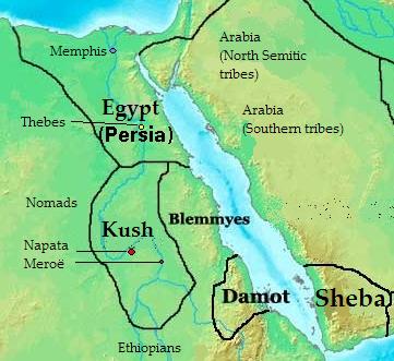
Summarium: Map of Southern Arabia and East Africa (Sudan + Eygpt) 400 bc
| Descriptio |
English: Map of kingdoms, states and tribes in 400 BC Africa.
Polski: Mapa królestw, państw i plemion w Afryce w 400 p.n.e.. |
| Datum | |
| Fons | Opus proprium |
| Auctor | Kubek15 |
| Other versions |
 |
Potestas usoris
I, the copyright holder of this work, hereby publish it under the following licenses:

|
Licet hoc documentum exscribere vel distribuere vel demutare sub GNU Liberarum Litterarum Licentiae conditionibus in editione 1.2 aut in ulla editione recentiori a Fundatione Liberarum Programmationis Partium publicata; praeterquam Sectiones Immutabiles et Verba Involucra Adversa et Aversa. Licentiae exemplar praesto est in sectione intitulata GNU Free Documentation License. |
This file is licensed under the Creative Commons Attribution-Share Alike 4.0 International, 3.0 Unported, 2.5 Generic, 2.0 Generic and 1.0 Generic license.
- Tibi licet:
- communicare – copiare, distribuere et committere hoc opus
- to remix – to adapt the work
- His condicionibus:
- attributio – You must give appropriate credit, provide a link to the license, and indicate if changes were made. You may do so in any reasonable manner, but not in any way that suggests the licensor endorses you or your use.
- aequa parte – If you remix, transform, or build upon the material, you must distribute your contributions under the same or compatible license as the original.
Tibi typum permissionis ligere licet.

|
This historical map image could be re-created using vector graphics as an SVG file. This has several advantages; see Commons:Media for cleanup for more information. If an SVG form of this image is available, please upload it and afterwards replace this template with
{{vector version available|new image name}}.
It is recommended to name the SVG file “Africa in 400 BC.svg”—then the template Vector version available (or Vva) does not need the new image name parameter. |


Historia fasciculi
Presso die vel tempore fasciculum videbis, sicut tunc temporis apparuit.
| Dies/Tempus | Minutio | Dimensiones | Usor | Sententia | |
|---|---|---|---|---|---|
| recentissima | 13:28, 17 Iulii 2010 | | 361 × 331 (28 chiliocteti) | Kubek15 | {{Information |Description={{en|1=Map of kingdoms, states and tribes in 400 BC Africa.}} {{pl|1=Mapa królestw, państw i plemion w Afryce w 400 p.n.e..}} |Source={{own}} |Author=Kubek15 |Date=2010-07-17 |Per |
Nexus ad fasciculum
Ad hunc fasciculum nectunt:
Usus fasciculi per inceptus Vicimediorum
Quae incepta Vici fasciculo utuntur:
- Usus in ar.wikipedia.org
- Usus in arz.wikipedia.org
- Usus in ast.wikipedia.org
- Usus in az.wikipedia.org
- Usus in be.wikipedia.org
- Usus in bg.wikipedia.org
- Usus in br.wikipedia.org
- Usus in ca.wikipedia.org
- Usus in ce.wikipedia.org
- Usus in cs.wikipedia.org
- Usus in cv.wikipedia.org
- Usus in da.wikipedia.org
- Usus in el.wikipedia.org
- Usus in en.wikipedia.org
- Usus in en.wikibooks.org
- Usus in eu.wikipedia.org
- Usus in fa.wikipedia.org
- Usus in fi.wikipedia.org
- Usus in fr.wikipedia.org
- Usus in ha.wikipedia.org
- Usus in hr.wikipedia.org
- Usus in hu.wikipedia.org
- Usus in hy.wikipedia.org
- Usus in id.wikipedia.org
- Usus in it.wikipedia.org
- Usus in ja.wikipedia.org
- Usus in ka.wikipedia.org
- Usus in ko.wikipedia.org
- Usus in lt.wikipedia.org
- Usus in mg.wikipedia.org
View more global usage of this file.