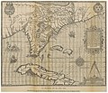
Fasciculus:1591 De Bry and Le Moyne Map of Florida and Cuba - Geographicus - Florida-debry-1591.jpg

Page contents not supported in other languages.
E Vicipaedia

Sua resolutio(4 500 × 3 480 elementa imaginalia, magnitudo fasciculi: 6.38 megaocteti, typus MIME: image/jpeg)

Hic fasciculus apud Vicimedia Communia iacet; in aliis inceptis adhiberi potest. Contenta paginae descriptionis fasciculi subter monstrantur.

Floridae Americae Provinciae Recens & Exactissima Descriptio Auctore Iacobo Le Moyne cui Cognomen de Morgues, qui Laudonierum …
Artifex
Titulus
Floridae Americae Provinciae Recens & Exactissima Descriptio Auctore Iacobo Le Moyne cui Cognomen de Morgues, qui Laudonierum …
Descriptio
English: …the most remarkable and important map, which has been preserved from the sixteenth century maps, of that part of the East Coast which lies between Cape Hatteras and Cape Florida … the first French map to show Florida … considered the most important map of Florida. - Johns Matthews Baxter A map of extraordinary rarity and seminal importance, this is one of the earliest and most influential maps of the American southeast ever published. Drawn by the French artist Jacques Le Moyne de Morgues c. 1565 and published by Theodore de Bry in 1591, this magnificent map details the Florida peninsula and Carolina coast from Cuba to the Bahamas, to “Prom Terra flag” or, as it is known today, Cape Lookout near Beaufort, North Carolina. The fascinating story of this map begins with the ambitions of the influential Huguenot Admiral Gaspard de Coligny. De Coligny, desirous of a French foothold on the American mainland sent the talented navigator Jean Ribaut to establish a colony. In 1562 Ribaut landed near the mouth of the St. John River, which he named F. Maij after the month in which he landed. Ribaut and his crew then sailed north along the coast until they discovered a large bay which they named Port Royal. Here they landed and established Charlefort after King Charles IX of France. This is the first mention of Port Royal on any map and is, along with Prom. Canaueral (Cape Canaveral), the only two sites in Florida to retain their French names through the following centuries of Spanish and English dominance. Having successfully established Charlefort, Ribaut returned to France to bring additional settlers and supplies. There he discovered his homeland to be in the midst of a religious war between the Catholic house of Valois and the Huegonot house of Bourbon, with whom he was associated. The conflict took Ribaut to England where involvement in a political plot saw him imprisoned. Meanwhile in less than a year the colony of Charlefort, beset by famine, an aggressive indigenous population, and a lack of supplies mutinied. Constructing a small adhoc sailing craft, the fifty or so mutinous settlers attempted to return to France. Lacking a proper navigator or notable sailing skills, the settlers would surely have died at sea had they not been picked up by a passing English ship. By 1564, a tentative peace had been established in France and, not one to see his ambitions thwarted, Admiral De Coligny planed a second expedition to the New World. With Ribaut imprisoned in England, De Coligny chose an under commander on the first voyage, Rene de Laudonniere, to lead the second expedition. Laudonniere landed and set up a settlement along the F. Maij (River May or St. John’s River) which he named Carolina. This second expedition also included the prominent French artist Jacques Le Moyne, who was commissioned to record and map as much of the region as possible Back in Europe, Ribaut had been released from prison and Coligny sent him, along with several ships and some 200 soldiers, to take command of the Carolina settlement. By this time the Catholic King of Spain, having heard about the French colony, dispatched the newly appointed Governor of Florida, Don Pedro Menéndez de Avilés, with orders to remove the “Heretic French”. After a brief skirmish with Ribaut’s ships, Menéndez de Avilés sailed south and established St. Augustine, the first permanent European settlement on the North American mainland. From St. Augustine, Menéndez de Avilés marched his troops overland to Carolina where they destroyed the fort and, in a shocking display of violence, slaughtered most of the settlers, including Ribuat. Laudonniere, Le Moyne, a few others managed to escape through the surrounding swamps and forests. Catching an English ship, the small group eventually made it to London where Le Moyne ultimately settled.
Datum 1591 (undated)
Dimensions Altitudo: 14 in (35.5 cm); Latitudo: 18 in (45.7 cm)
dimensions QS:P2048,14U218593
dimensions QS:P2049,18U218593
Accession number
Geographicus link: Florida-debry-1591
Source/Photographer

Le Moyne de Morgues, J., Brevis Narratio Eorum Quae in Florida Americae Provicia, in De Bry, J., Grands Voyages, part II, 1591 edition.

Permissio
(Reusing this file)
This is a faithful photographic reproduction of a two-dimensional, public domain work of art. The work of art itself is in the public domain for the following reason:
Public domain

This work is in the public domain in its country of origin and other countries and areas where the copyright term is the author's life plus 100 years or fewer.


You must also include a United States public domain tag to indicate why this work is in the public domain in the United States.
The official position taken by the Wikimedia Foundation is that "faithful reproductions of two-dimensional public domain works of art are public domain".
This photographic reproduction is therefore also considered to be in the public domain in the United States. In other jurisdictions, re-use of this content may be restricted; see Reuse of PD-Art photographs for details.
Other versions

Captions

Add a one-line explanation of what this file represents

Items portrayed in this file

depicts Anglica

MIME type Anglica

image/jpeg

checksum Anglica

4b8188a6e693b583015d144722e72b3c52e989fc

data size Anglica

6 694 512 byte

3 480 pixel

4 500 pixel

Historia fasciculi

Presso die vel tempore fasciculum videbis, sicut tunc temporis apparuit.

Dies/TempusMinutioDimensionesUsorSententia
recentissima19:21, 22 Martii 2011Minutum speculum redactionis 19:21, 22 Martii 2011 factae4 500 × 3 480 (6.38 megaocteti)BotMultichillT{{subst:User:Multichill/Geographicus |link=http://www.geographicus.com/P/AntiqueMap/Florida-debry-1591 |product_name=1591 De Bry and Le Moyne Map of Florida and Cuba |map_title=Floridae Americae Provinciae Recens & Exactissima Descriptio Auctore Iacobo Le

Ad hunc fasciculum nectit:

Usus fasciculi per inceptus Vicimediorum

Quae incepta Vici fasciculo utuntur: